
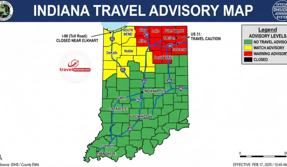

The Indiana travel advisory map is an important resource for anyone planning to travel across the state. It helps drivers understand current travel conditions by showing advisory levels for each county. Before heading out during severe weather, emergencies, or unsafe road conditions, checking the map can help travelers make better decisions.
Many people search for the Indiana travel advisory map by county because conditions can change from one area to another. A road that is safe in one county may have dangerous conditions just a few miles away. The map gives residents and visitors a clearer view of what is happening across Indiana.
What Is the Indiana Travel Advisory Map?
The Indiana travel advisory map is an online tool that displays travel conditions across Indiana counties. It is designed to help people understand whether travel is normal, requires caution, or should be avoided due to safety concerns.
The map is commonly used during winter storms, heavy rain, flooding, ice conditions, and other events that can affect road safety. Instead of relying only on general weather reports, travelers can check county-level information before starting their journey.
The state of Indiana uses different advisory levels to communicate travel risks. These levels help residents understand how seriously they should take current road and weather conditions.
Indiana Travel Advisory Map by County Explained
The Indiana travel advisory map by county provides information based on local conditions. Each county can receive its own travel status depending on reports from local officials.
An advisory level means travelers should use caution because conditions may create difficulties. Drivers should slow down, stay alert, and prepare for possible delays.
A watch level indicates that conditions may create a higher risk for travelers. During this situation, people are encouraged to avoid unnecessary trips and stay updated as conditions develop.
A warning level represents the most serious travel restriction. It means conditions may be dangerous, and only essential travel should be considered. Emergency workers and people dealing with urgent situations may still need to travel, but general driving should be limited.
How to Check the Current Indiana Travel Advisory Map
People searching for the current Indiana travel advisory map usually want quick information before leaving home. The map can help answer important questions about whether roads in a specific county are safe for travel.
Travel conditions can change quickly, especially during storms or emergency situations. A county that has normal travel conditions in the morning may have a different status later in the day if weather becomes worse.
Checking the updated Indiana travel advisory map before traveling is a simple step that can help avoid unsafe conditions. It is also useful for people planning long-distance trips through multiple counties.
Indiana Travel Advisory Map and Road Closures
Many travelers confuse travel advisories with road closures, but they provide different information. The Indiana travel advisory map shows the overall travel status for counties, while individual road closures may happen because of accidents, construction, flooding, or other problems.
A county may have a travel advisory even when some roads remain open. At the same time, a specific road may close even if the county does not have a major travel restriction.
For this reason, drivers should check both travel advisory information and current road conditions before making important trips. Looking at multiple sources gives a more complete picture of what is happening on Indiana roads.
INDOT Current Indiana Travel Advisory Information
Many people search for the INDOT current Indiana travel advisory map because they want highway and road condition updates. The Indiana Department of Transportation provides information about state roads, traffic conditions, construction areas, and travel-related updates.
The travel advisory map and INDOT information work together. The advisory map helps users understand county conditions, while INDOT information can provide more details about specific transportation issues.
Drivers traveling through Indiana should consider checking both resources, especially during winter weather or major travel periods when road conditions may change quickly.
Indiana Travel Advisory Map Updates During Severe Weather
Weather is one of the biggest reasons Indiana travel advisory updates happen. Snow, ice, freezing temperatures, strong storms, and flooding can create dangerous driving conditions within a short time.
County officials review local conditions and update travel information when needed. This local approach allows each county to respond based on its own situation instead of using one travel status for the entire state.
The updated Indiana travel advisory map gives travelers a better understanding of where problems exist and where normal travel may still be possible.
Is There an Indiana Travel Advisory Map App?
Many users search for an Indiana travel advisory map app because they want quick access while traveling. Today, most people use the official online map through a smartphone browser instead of a dedicated application.
The mobile-friendly map allows travelers to check county conditions from their phones. Saving the page on a mobile device can make it easier to access during emergencies or changing weather.
Having updated travel information available while on the road can help drivers avoid unsafe routes and make better travel choices.
Indiana Travel Advisory Map and COVID-19 Information
During the COVID-19 pandemic, searches for the coronavirus Indiana travel advisory map increased as people looked for location-based updates. However, travel advisory maps are mainly focused on road conditions and emergency travel situations.
Health guidance and travel rules during the pandemic were handled through separate public health resources. The travel advisory system continues to focus on road safety and local travel conditions.
Why Checking the Indiana Travel Advisory Map Matters
The Indiana travel advisory map gives travelers useful information before they begin a trip. It can help people avoid dangerous areas, prepare for delays, and understand changing conditions.
Drivers should always consider weather forecasts, road conditions, and official travel updates together. A few minutes spent checking current information can make a big difference when traveling during uncertain conditions.
The map is especially helpful for commuters, families traveling across counties, truck drivers, and anyone planning a longer road trip through Indiana.
Frequently Asked Questions
What is the Indiana travel advisory map used for?
The Indiana travel advisory map helps people understand travel conditions across different counties. It shows whether travelers should continue normally, use caution, or avoid unnecessary travel.
How can I check the Indiana travel advisory map by county?
You can check the map online and select individual counties to view their current travel status. County information helps travelers understand local conditions before driving.
Does the Indiana travel advisory map show all road closures?
No. The map shows county travel conditions, but it does not include every individual road closure. Specific road problems may require checking additional transportation updates.
How often is the Indiana travel advisory map updated?
Updates depend on changing conditions and reports from local officials. During severe weather, information may change several times throughout the day.
Is the Indiana travel advisory map available on mobile phones?
Yes. The map can be accessed through mobile browsers, making it convenient for travelers who need updates while away from home.
Conclusion
The Indiana travel advisory map is a helpful tool for understanding current travel conditions across the state. By checking county updates before driving, travelers can better prepare for changing road situations.
Weather and emergencies can create unexpected challenges, but staying informed can reduce risks. Whether planning a daily commute or a long road trip, checking the latest travel information is a smart step.
The best travel decisions come from using updated information and paying attention to local conditions. The Indiana travel advisory map makes it easier for drivers to know what to expect before they begin their journey.